Queensland > South Queensland > Canungra
Mt. Tamborine
| Type | |
| Conditions | NW-SW |
| Height | 1916ft/584m ASL |
| Rating | PG4; PG2 if under supervision of Instructor or Club SO. HG: Supervised |


Sealed road to the site along Main Western Rd Mt. Tamborine (Refidex Gold Coast Map 23, L4).
Landowners - ?
Contact/Responsible
CHGCSee also
Description
The site is only to be used by CHGC pilots or visiting pilots in the company of a CHGC member.
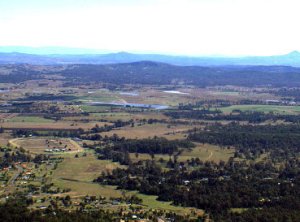
Tamborine Mountain Launch overlooks the beautiful Canungra Valley and is approximately 30km from the Gold Coast and 70km from Brisbane. With it's breath-taking views and scenery, it's clean mountain air and local art shops, quaint coffee shops and restaurants, and with it's country markets and friendly atmosphere, it is a popular site any weekend for pilots and spectators.
Mount Tamborine takes a general Westerly wind direction, and as such it is "on" quite often in the Winter. It is popular for high glide top to bottom sled runs early in the morning, it is good for boating around mid-day on buoyant days or for going on local cross country flights. Winter day thermals can be smooth and enjoyable and on electric blue-sky blue-thermal days, the view of the Gold Coast is simply breath-taking.
As the coast is to the east (with airspace ceiling that steps down rapidly in altitude), you have to punch headwind towards the west to do any distance. As such, the XC club record for Tamborine is relatively short compared to the Easterly sites.
Takeoff
Mount Tamborine Launch is open to club members and visiting pilots. It is a prime spectator spot on a main road, and is common for the Launch area to be full of tourists taking photos of the many colourful gliders.
Toilets at launch site. Shops within 5 mins drive north.
Landing
There are two official bombouts. Our property on Wagon Wheel Road and the adjacent public land, and the Hugh Mahoney Reserve on the Mundoolin Connection Road. There is also land which can be utilised in an "emergency". It is the first open paddock at the edge of the trees along Wagon Wheel Road on the north side of the road (or the paddock adjacent to the second house on the right as you fly out from launch). Please see the Online Maps page for more detail. Landing outside these 3 areas is against CHGC policy.
When pre- or post- thermic, our main landing area is easily makeable by all paragliders and hang gliders. However this changes dramatically when thermals are present. Landing short at Tambo is a safety issue. Landing on the road is illegal and extremely risky and leaves ourselves open for litigation. Landing short at Tamborine is the result of not assessing the conditions correctly and it is considered extremely poor judgement to land short of the bombout after scratching low in front of launch or out on the left hand spur.
The CHGC enforces a Three Strike Rule that applies if landing in a No-Landing area. They are as follows.
1st Infringement- $50 fine.
You can avoid this fine by emailing your respective SSO within one week to explain your decisions that lead to this error. You can use the Report an Incident form on this website to do so.
2nd Infringement- $50 fine.
A mandatory one off payment.
3rd Infringement - Site Ban.
If within 6 months of the first infringement, then a 3 month ban from that site during which time the pilot should seek further training/advice from a SSO or instructor.
The top landing area is the TMSA sports complex on Long Rd, Tamborine Mountain. If at all possible we are to land on the undeveloped portion of the land up near the road. If you have to land in a playing field, use the square one. Stay away from the oval one. Especially the cricket pitch in the centre.
Aerial view of Bombout

Bomb out from the air (click image to enlarge)

Main Bombout (click image to enlarge)

Top Landing

Launch: Sealed road to the site along Main Western Rd Mt. Tamborine
Bombout: Main bombout can be accessed from Traveling down through Canungra then following Mundoolun rd and turning right into Wagonwheel Rd. Access via first vacant block of land on the left after Fenwick drive.
Flight
CTA: 7500ft
Hazards / Comments
The first thing you'll notice when standing on Tamborine Launch is the amount of trees between you and the landing area.
The thing with Tamborine is there is little room for error, and it catches new pilots out EVERYTIME. No matter how much the Safety Officer emphasises on the following points, there is always one person that doesn't take it in. Don't be one of those pilots. Please read the following carefully, so that you don't end up in the trees and risk injuring yourself.
There can be very strong thermic cycles at Mt. Tamborine. Essentially what that means is that when air is going up very fast at Tambo, air very close to it is going down very quickly. A pilot will see another pilot going up in the near distance and head out, only to suddenly find themselves in extreme sink with little hope of making either the distant pilot or the landing area! Combine an unpredictable strong sink cycle with strong head wind and it will almost guarantee you end up in the trees, so the number one rule with Mount Tamborine is:
If you are not going up, head out to the landing field.
Now in case you're one of those people that skip over red bold writing, here it is again:
If you are not going up, head out to the landing field.
If it is blowing from the north, it will almost certainly be rough air. Avoid flying in the northern bowl if it strong north otherwise you'll be flying in rotor.
If it blowing strong from the south, judge your glider very carefully, otherwise you will not make the bombout. There is nothing but trees in between.
Powered operations are prohibited at all CHGC launches.
No acrobatics within a cylinder of 150m radius around any CHGC launch.
First Aid box at the shelter in the main bombout.
Spring and Summer see strong thermals with the possibility of major sink cycles
A common situation is a westerly wind in the morning and a SE or NE sea breeze reaching Tamborine launch in the early afternoon. Once you are about to launch a Hangglider it is hard to see the wind streamers behind you and it is worthwhile to be assisted by a sensible person who can watch behind you for the onset of tailwind.
Be aware of the wind strength and the distance to the bombout areas.
Beware the level and degree of the sink cycles.
Launch slope is shallower than ideal and is troubled by turbulence from the shelf in front of the launch and from the trees on the sides of the launch.
Face landing for Advanced pilots only when there are no public or Hangliders on launch.
Refrain from setting up landing approach low over houses near main bombout.
The trees on the north side cause turbulence and wind shadow in a northerly wind.
Beware of 7500ft height limit. (CTA)
Because of the distance from the launch to the main landing site on Wagonwheel Rd all paraglider pilots need to fly in such a manner that a safe landing in the designated landing area is the primary flight plan if they are not gaining height. i.e. if the pilot is not gaining height, they need to be flying towards the landing area, not go scratching low hoping to find lift.
This site is rated Intermediate for Paragliders, restricted pilots are to fly only if under supervision of an Instructor or Club Safety Officer.
Restricted pilots must be aware of the privileges and limitations for their rating, paying particular attention to clause (g) when flying Mt Tamborine.
Map information
